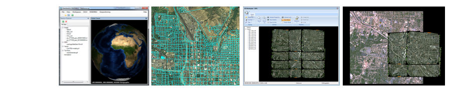
Log-in | Support and Help | Contact
GeoGenesis™ Overview | Features | Version Info | Support | FAQs | Pricing and How to Buy | Downloads
GeoGenesisLE™ Overview | Features | Version Info | Support | FAQs | FREE | Downloads
OmniDEM™ Overview | Features | Version Info | Support | FAQs | Pricing and How to Buy | Downloads
FeatureXTract™ Overview | Features | Version Info | Support | FAQs | Pricing and How to Buy | Downloads
Overviews | Developer Information | Support | FAQs | Downloads
subglobal7 link | subglobal7 link | subglobal7 link | subglobal7 link | subglobal7 link | subglobal7 link | subglobal7 link
subglobal8 link | subglobal8 link | subglobal8 link | subglobal8 link | subglobal8 link | subglobal8 link | subglobal8 link

The GeoGenesis® Product Line small logo

Welcome to the GeoGenesis® Experience

Tired of using old, cumbersome tools from established geosoftware companies? We were too. We did something about it: Introducing GeoGenesis.

GeoGenesis is a unified imagery processing platform suite specifically designed to support modern geodata production services. The suite is comprised of the core GeoGenesis application, with several supplemental optional components (see below).

With GeoGenesis you won’t get a package attempting to be all things to all people. Instead, it’s 100% geared to supporting production in the photogrammetric/mapping, feature extraction, and digital elevation modeling (DEM) generation and management domains. Using it will help your bottom line by increasing the efficiency of your end-to-end processing chain. GeoGenesis provides improved and patented approaches in modern processing and gives you the tools you need most to maximize time and cost savings and help enhance your profitability and output.

Test GeoGenesis (and the absolutely FREE GeoGenesisLE) today and see why more and more people are realizing that our new affordable tools are "the secret to your geo success"™.

GeoGenesis is composed of the following components:

Serving as the core application of the suite, GeoGenesis v1.4 is an imagery processing and photogrammetric workstation giving you complete control over your data. Using GeoGenesis you can rapidly orthorectify aerial and satellite imagery one at a time or in batch mode. In addition, GeoGenesis provides you the ability to perform bundle adjustment on multiple images assisted by automated tie point selection between overlapping images. GeoGenesis includes pan-sharpening capabilities to fuse high-resolution panchromatic imagery with lower resolution color imagery. The GeoGenesis mosaicking capabilities allow you to combine multiple images into a single orthomosaic, and our radiometric balancing capabilities help eliminate any visible seams using either color or grayscale source date. Geared totally for production applications, GeoGenesis is the tool of choice for your imagery processing and photogrammetry needs.

Visit the GeoGenesis product page to learn more.


Enhanced for 2009, GeoGenesisLE is a free geospatial data viewer allowing you to display imagery, elevation, and vector data with an easy to use graphical user interface. Using GeoGenesisLE you can quickly view single or multi-band satellite and aerial imagery with simple band selection menus to display natural color and false color views of the scene. You may also overlay geospatial vector data onto underlying imagery and elevation data. In addition to rapid panning and zooming capabilities, GeoGenesisLE provides you the ability to convert and save imagery from NITF format to GeoTIFF while maintaining important registration information including RPC data for commercial satellite imagery. Whether displaying or converting data, GeoGenesisLE will be the tool you turn to.

Best of all, it’s free. Yes, free. Learn more about and download GeoGenesisLE today.


If you need accurate and up-to-date digital terrain elevation data, then OmniDEM™ is your solution. Digital Elevation Models (DEMs) are essential to a variety of geospatial production applications, such as GIS, digital terrain database generation, orthorectification, and watershed analysis. Redesigned for 2009, OmniDEM™ provides you the ability to efficiently extract accurate elevation models from stereoscopic imagery as well as full editing capability to refine existing DEMs. The OmniDEM™ easy to use interface unlocks the secret to generating accurate DEMs from overlapping satellite and aerial imagery.

Visit the OmniDEM™ product page to learn more.


FeatureXTract™ is a geospatial site-modeling system composed of both automated and semi-automated tools. These allow you to rapidly extract 3D buildings and related features from aerial and satellite imagery.  Updated for 2009, FeatureXTract™ employs a simple split-screen interface eliminating the need for active stereo displays in 3D feature extraction.  Using FeatureXTract™ you can quickly extract accurate 3D site models even on a laptop and export them for use in a variety of applications, including digital terrain database generation.  With FeatureXTract™, building an urban environment is now simple, rapid, and most importantly accurate.

Visit the FeatureXTract™ product page to learn more.


Recent News of note:

Sanborn Support GeoGenesis has become a core application in supporting the US Army Corps of Engineers Topographic Engineering Center BuckEye Program. As a subcontractor to Sanborn (Colorado Springs, CO), GeoGenesis is used for complete end-to-end processing, to include generating the output orthographics and balanced mosaics in their original expanded radiometric resolutions. Read more about the BuckEye examples in Showcases.


Durham, NC GIS The GeoGenesis development cycle had multiple technology tracks, and these had to have equal applicability to both DoD and civilian production requirements. To achieve this, our software engineers worked closely with senior personnel from the Durham, NC GIS office. This step-by-step tool definition ensured that the GeoGenesis development addressed the broad needs of today’s progressive geospatial users. Read more about the Durham examples in Showcases.

| About Us | Site Map | Privacy Policy | Contact Us | ©2007 IAVO Research and Scientific